Share

Tuesday 9 July 2013

End of Dig Wrap-up Part 4: In and Around Dunning

As with every SERF fieldschool, we aim to give our students a taste of as many archaeological techniques as possible alongside our main excavations. This year, our students had a full complement of projects which they could include in their portfolios, including walkover survey, geophysical survey, standing building survey, topographic survey and community outreach activities like the Dunning Big Dig. Here are some of the results from these projects, rounding out another superb SERF Project fieldschool in Dunning.


Topographic survey at Kincladie Wood Roman Camp


The upstanding north ramparts of a Roman temporary camp survive in Kincladie Wood on the edge of Dunning.
Relatively little is known about the Roman temporary marching camp at Dunning. The only upstanding remains are situated in Kincladie Wood and apart from some very small-scale excavations in the 1970s and 1990s, most of our evidence for the camp comes from aerial photography. This has been used to trace the perimeter of the fort enclosing an area of around 46 hectares, sufficient to hold an entire army of soldiers and their logistical support. The western entrance of the fort was revealed in advance of the construction of houses along Romangate, Dunning, and produced pottery from the middle of the second century AD. The Perth Road runs through a similar entrance on the north side of the fort. All the entrances are defended by a simple outwork or titulus bank and ditch.


Aerial and profile views of the Roman camp ramparts and titulus gate

The survey focused on the Kincladie Wood section of the defences, recording the main bank and ditch of the camp, as well as the surviving remains of the titulus bank and ditch beyond the northern entrance. At the west end of the rampart, the survey might suggest the beginning of the corner of the camp, in contrast to the plan which shows this in the field beyond. At the east end of the rampart, the survey may have just picked up the entrance before being cut by the road. An additional low bank to the south of the main rampart looks likely to be associated with drainage in the boggy area of woodland.

Much remains to be revealed about Dunning’s Roman camp: its date remains uncertain, part of its extent remains unknown, and there is no known evidence of activity in the interior associated with its use. Our survey of this part of the monument was a brief training exercise, but it re-opens these questions for future research.

Dunning Big Dig and Beyond

University of Toronto student Cait uncovers an early wall in a back garden in Dunning
This year's Big Dig was a series of events across the first two weeks of the fieldschool, beginning with the Wee Big Dig at Dunning Primary School and five days of test pitting in the back gardens of interested volunteers across the village. You can read more about the results at our Dunning Big Dig blog.

Loom weights neatly stacked against the wall of the abandoned Weaver's Cottage on Thimble Row
Two of the Big Dig test pits were kept open and extended for excavation in the third week by the SERF Project with the help of ACFA volunteers. One of these was in the Weaver's Cottage on Thimble Row, a unique survival from Dunning's heyday as a weaving trade hub. Further excavations here revealed more about the everyday life of weavers a century ago and beyond, plus evidence of earlier walls.

A section of the early medieval monastic enclosure or vallum ditch found in a back garden north of St Serf's
A test pit at Castle Cottage adjacent to Dunning Primary School, where a possibly early monastic vallum ditch was found and radiocarbon-dated to the 8th century in 2007, was extended across the garden and successfully located the vallum ditch in this area. This was not excavated but planned and surveyed in situ. This work shows that early medieval features still survive in the village and this will help us plan future excavations.

Monday 8 July 2013

End of Dig Wrap-up Part 3: Leadketty


Leadketty: mysterious to the end! After three weeks of hard toil, and the investigation of dozens of pits, postholes and stakeholes as well as digging a ditch, palisade and two fence lines, the big questions about what was going on in and around the big earthwork enclosure and when all of this was happening remained frustratingly unresolved. Of course, we eagerly await the outcome of the post-excavation analysis of samples which should provide dating evidence and environmental context – but that means a wait of many months before we can really start to make sense of the archaeology we found. This means that in ways this was a frustrating excavation, but enlivened by a great team, some fine banter on-site, hot sauce in abundance, and some creative photography from Helen!

Jamie, day 17

The main target of the excavation was the big, putative causewayed enclosure. Ultimately, we did find part of the ditch of this monument, but it proved extremely challenging to excavate due to the nature of the subsoils, ditch fill and dry weather conditions. Nonetheless, Steve, Eva, then Scott, Chris, Jamie, Ben and Kirk were up to the challenge and mattocked the ditch into submission. Their brutal handiwork revealed a rather boring ditch, but at least we found it! By contrast, features in the rest of the trench were more easily spotted and excavated, including an amazing prehistoric fence line defined by a series of closely spaced postholes.

The palisade seemingly enclosing the causewayed enclosure

This fence line seems to be associated with the causewayed enclosure, perhaps indicating a larger enclosure encircling it, or a screen or elaborate entranceway (we identified two large possible gate posts). Some fine posthole excavating, often utilising ladles and spoons, revealed the complex and variable nature of this boundary. Amazing trowel (and spoon) work was evident all over the big trench, with plenty of small features cut into gravel and silt to keep everyone very busy. These remains suggest there were some timber structures within the causewayed enclosure, as well as at least two fence lines, but how these relate chronologically to one another remains to be seen.

As is often the case with excavation, there are more questions than answers at this stage, but none of this would have been possible without a brilliant and hard-working team who made each dry, dusty day on site a pleasurable experience!

Yours,
Kenny and Dene

The LK13 team

End of Dig Wrap-up Part 2: St Serf's

Week 3 was pretty wild! As is the rule with most seasons, all the biggest news emerged in the last few days of the dig. Since our last update, Trench 04 revealed a large and incredibly unexpected revetment wall which we will return to below. But first, a wrap-up of all our trenches in and around St Serf's Parish Church, Dunning.

Trenches 05 and 06 were situated just northeast of the churchyard, just above the Dunning Burn. Both revealed surprisingly shallow deposits bottoming onto what appeared to be the former riverbank gravel, with Trench 06 (extending as far as the embankment of the river) showing how some of this area has been artificially raised and leveled in modern times. Locals inform us that the seemingly placid Dunning Burn was prone to flooding even with these improvements, although this happens less frequently now that there are numerous tree plantations upstream. Trench 05 did include two sherds of medieval pottery and a stance for a modern drystone structure, but along with the sparse features of Trench 06 indicates that the riverfront area was used only for light agricultural activity associated with the old schoolhouse before becoming the village midden in the late 19th century and the site of a Scout hut in the 20th century, which stood until recently.

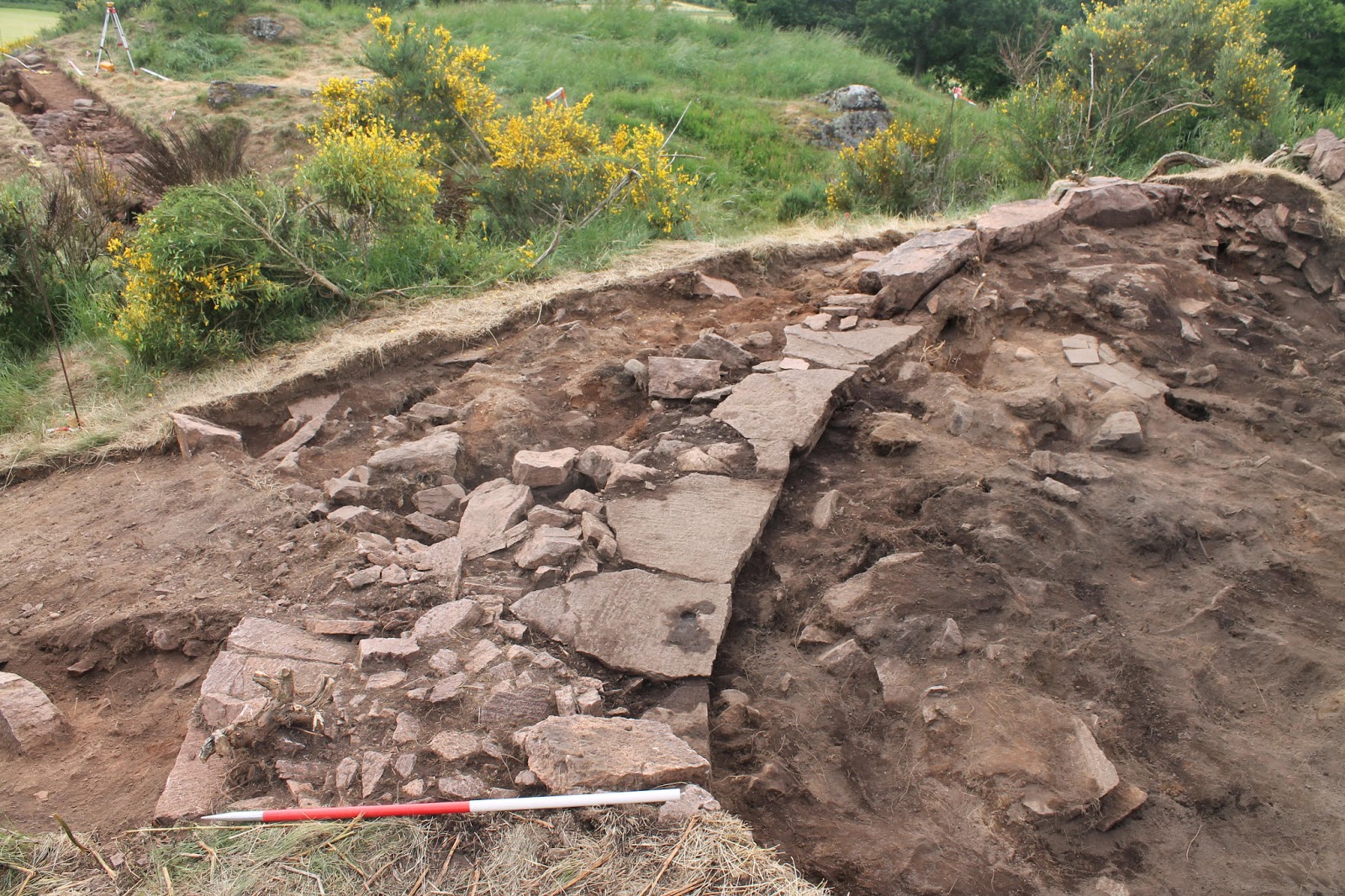
Trench 04 was located along the modern boundary wall of St Serf's churchyard. After the Victorian midden layers, the modern structures, and the medieval garden soil, we reached a layer of stone settings about a meter below the ground surface. When we hit some very large sandstone slabs surrounded by gravel in the middle of the trench, we figured we were approaching bedrock. This 'bedrock' soon became a wall of large, squared blocks of sandstone, standing up to three courses, running broadly north to south. This wall had only one face; it was backed by smaller boulders and clay, as opposed to the loose gravel and sand on the outward side.
A large wall running N-S runs underneath the modern churchyard boundary wall

The gravel surrounding the wall was certainly not 'natural' either, as it had medieval pottery and slag mixed in it. Both the wall and this gravel layer rested on the natural bedrock. Bedrock also appeared behind the wall but at a considerably higher level than the one on which the wall was built. So our current theory is that this wall was a revetment or retaining wall rather than a rampart.
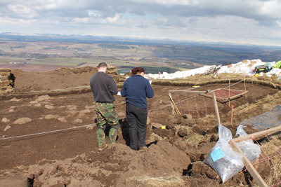
Trench 04 in context: Sven's ranging poles mark the wall as it appeared in the trench, with the rest of the St Serf's team marking the apparent line of the wall.

So is this the early medieval monastic boundary we had hoped for? It is certainly not the 8th-century vallum ditch encountered elsewhere in the village, but as seen in the photo above, it could still have acted as the edge of the platform on which the medieval church was built. The only dating evidence is that the wall was leveled and filled in with gravel and sand mixed with medieval pottery, indicating that this took place in the medieval period. As usual, more questions than answers here, but very exciting nonetheless!

Trench 07, along the north wall of St Serf's square tower, showing pre-12th century foundations

And while this was going on, we opened another small trench to investigate the origins of St Serf's square tower itself.

The excavations at the church tower have been very successful in uncovering evidence for an early medieval church at Dunning, possibly dating back as early as the time of St Serf himself (around AD 700). The area we excavated was very restricted (only 3 x 1 metres) due to the presence of the post-medieval graveyard, and modern service trenches for the church. The foundations of the 12th century church and a medieval burial ate into this space leaving only a tiny patch of pre-12th century deposits intact and making it very difficult to excavate. Despite these problems, this area turned out to be highly significant, as it showed the foundations of an earlier stone building that had been re-used by the medieval masons! Pre-12th century stone churches are very rare in Scotland, with only a couple of other examples known. Even better, there was an earlier burial running under this foundation, which will enable us to get a good scientific date for the building, and shows that there was an even earlier focus for burial, probably a wooden church under the present church tower.
12th-century tool marks on the ashlar masonry of the tower, long obscured by soil buildup

Another surprise was the quality of preservation of the 12th century stonework, which showed the mason's toolmarks from working the stone blocks of the church. These had been preserved by post-medieval deposits from the effects of industrial pollution (acid rain) of the 19/20th centuries, and show how much the soft sandstone of the present building has been damaged in the last few hundred years.

All in all, a very successful season at St Serf's!

Thanks for reading,
Adrian and Ewan

End of Dig Wrap-up Part 1: Kay Craig

The well-built wall of the circular structure


Well! That's us finished up at Kay Craig after the smoothest hillfort backfill in SERF Project history. Done by 2pm and down to the Kirkstyle beer garden for a couple of pints before the end of dig BBQ.

In the final week we continued to explore the circular structure at the top of the hill. Our provisional interpretation is that this is a site that has seen several phases of use.

One of the first phases is evident from a large ashy and charcoal rich layer across the top of the bedrock - possibly material from a burning event that has later been spread across the site to level out the uneven bedrock (unfortunately no finds from this layer so we will have to wait and see what the carbon dates say).

On top of this layer the circular structure with concentric boundary wall reminiscent of the broch at Castle Craig has been built. The structure wall is much smaller than a typical broch wall at 1.2m wide so we think this is probably a 'dun' site or smaller enclosed outpost, perhaps contemporary with the broch, although again we have to wait for carbon dates to be sure.

Later some of this structure wall has been disturbed by a combination of rabbit burrows, vegetation roots and probably some robbing of stone.

Some repairs have been done as the site was reused - this time with more rough angular stone blocks making up part of the wall while reusing the base course of the earlier structure. There was also a possible turf component to the structure and a small secondary hearth in a disturbed occupation layer. This hearth was up against one side of the reused structure and had enough slag nearby to suggest it was a secondary hearth for metal working. Several whetstones and the crucible plus a LOT of ash were near this spot as well.

This structure was then knocked down or fell down creating a layer of tumbled stone which was where most of the possible medieval finds came from.


Rock-cut ditch packed with stones

Meanwhile the ditch and bank were excavated down to bedrock. The ditch looks like it has been deliberately filled in with a lot of flat angular stones to level the uneven bedrock surface and also to provide a more usable surface, perhaps for keeping livestock on or creating more space for other activity on the site.

The bank is presumably contemporary with the ditch as it follows the line of the ditch and a large quantity of the angular stone in it it has likely come directly from the quarried out ditch. No more finds in the ditch since the possible Iron age and possible medieval pottery so we will be waiting on yet more carbon dates to compare the date of this part of the site with the structures on the hill and the other sites in the area.

So as of yet there is all to play for but regardless of what period the activity on this site spans it is a really interesting addition to our project data.

A big thanks to everyone who helped out on the site, particularly our regulars; Veronica, Neil, Andrew, Bec, Jennifer, Alex and Lorraine. Special thanks to our superb supervisor Yvonne who kept it all running smoothly. And thanks to the locals who came to visit, the landowners who made us welcome and Mrs Kinnard for pointing us at the site in the first place.

Onwards and upwards to the next hillfort!

Cheers,
Cathy and Tessa

Tuesday 2 July 2013

Bottles, Stones & Pottery: a note from our Finds Czar Jules McHale


Some of the Greatest Hits from the Victorian midden in the St Serf's trenches
Comforted by Pringles, giant buttons and a variety of visits from our SERF team and residents of Dunning, this year’s small finds processing has been carried out at the wee school in Dunning Village. In this season's infancy, the finds recovered were predominantly from our trenches at Kirk Wynd, behind St. Serf’s church. We have amassed a plethora of bottles, clay pipes and pottery from a late 19th/early 20th century midden site.

An example of late medieval green-glazed pottery, showing the thumbprint of the potter
Throughout the season, St Serf's has produced medieval pottery sherds, while Kay Craig has produced multiperiod material from early Iron Age pottery to a possibly medieval crucible for melting precious metals.

Leadketty, with its complex and numerous features, has been sterile of any finds so far! But its sterile condition is very different from the situation in last year's henge and palisaded enclosure excavations, where numerous contexts turned up Grooved Ware ceramic and burnt deposits. This does infer that the monuments were most likely kept intentionally clean. In this case, there is important evidence for prehistoric ritual activity even in this absence of artefacts. Both rich and sterile excavation conditions provide us as archaeologists with information that can potentially shape our interpretations and understanding of the sites.


A very unusual quartz pivot stone, split in half, found in the St Serf's trenches
All of the small finds that have been recovered from the series of trenches at SERF 2013 have been washed where appropriate, catalogued and stored to enable potential further study. To date, approximately 500 finds in total have been recorded. The assemblages of artefacts vary across lengthy time periods.

Monday 1 July 2013

Happy St Serf's Day!

Prof. Steve Driscoll slays the Dragon as Mairi invokes St Serf
Fortuitously for us in the St Serf's trenches, July the 1st is St Serf's feast day. St Serf is an obscure Pictish saint whose dossier only dates back to the 12th century but incorporates much earlier material. One of the most famous legends which have grown up around this shadowy figure is his slaying of a dragon with his staff, which is said to have occurred in Dunning. Taking the initiative, our student volunteers crafted a dragon last night, which we then flew over our trench today. At the end of another grueling day, our supervisor Prof. Steve Driscoll re-enacted the slaying of the beast, with our trusty ranging pole representing St Serf's venerated staff. Huzzah!

The Dragon flying over our trench.

Sunday 30 June 2013

Early foundations and medieval structures at St Serf's

Earlier foundations beneath the square tower of St Serf's
Amazing things are happening in the St Serf's trenches. Trench 07, a small architectural slot at the base of the 12th-century square tower, has revealed the foundations of an earlier stone structure! In the photo above, you can see the mortared rubble foundations of the 12th-century tower as it joins the nave. But about halfway down the trench, the foundations change to a setting of stones on a slightly different axis, set into a trench filled with rubble. What's more, this rubble contains flecks of disarticulated human bone, meaning it has cut into earlier burials. Whatever this all relates to, it is earlier than the 12th century, so this is where it gets exciting!

The mystery medieval stone setting in Trench 04 outside the churchyard wall
Meanwhile, outside the churchyard wall (and some 30cm beneath it) we have finally gotten through the garden soils filled with medieval ceramic (see below). At a depth of over a meter, our students' quality troweling skills have revealed numerous stone settings, including the one pictured above. This feature in particular has turned up bits of burnt bone and charcoal so far, so we may be seeing in situ settlement evidence, predating the modern extension of the churchyard ...stay tuned to find out what it is!

Medieval potsherds from Trench 04 and 05
Meanwhile, our Open Day today included brand-new 'Churchspotting: How to Read a Medieval Church' tours of St Serf's led by Dr Adrián Maldonado, which were a big hit with the locals and will hopefully run again next year. Week 3 at St Serf's is going to be a big one!

Thursday 27 June 2013

Updates from the end of Week 2

St Serf's


Trench 04 is now down to the medieval subsoil.
It took us over a week to get through the modern midden and structures in Trench 04, and we are now well into preserved, possibly medieval layers. The finds we are getting at our current level are fragments of medieval redwares, white gritty ware (12-14th century) and some later green glaze, but they are all quite abraded fragments so we are still in what are essentially garden soils. Here's hoping they are sealing earlier features!

Meanwhile, in Trenches 05 and 06, we have found out a lot about the modern history of the village, especially the impressive feats of early modern engineering that reclaimed land from the riverbank. Trench 06 extends from the churchyard wall down to the Dunning Burn and shows that most of this area is actually made ground postdating the modern embankment of the river. And all done without the help of JCBs!

The 19th-century embankment wall and our trench through the made ground reclaimed from the ancient riverbank.

Kay Craig

The massive outer wall of the structures at Kay Craig.

Excited update! The bedrock wall face we extended the trench to investigate has turned out to be a wall after all! Alex uncovered courses of faced stone under the large bedrock chunks with lovely wee chock stones packing the gaps between the wall and the bedrock face. Now we are uncovering this fully to start to investigate its relationship to the structure on the top of the hill.


Open Day this Sunday!

Don't forget to swing by Dunning for our Open Day this Sunday June 30th! See our previous post for more details.

Wednesday 26 June 2013

SERF Open Day this Sunday!


Here is the line-up of events taking place on the SERF Open Day this Sunday June 30th!

  • Open Day at St Paul's Church Hall, 11am-4pm: Here you will find stalls, photos and artefacts from our excavations around Dunning and Forteviot, including Roman finds from Castle Craig Broch. Learn about the ongoing Dunning Big Dig and see some of the finds from this year so far!

View Dunning Saint Pauls Church in a larger map

  • Leadketty guided site tours, 12pm and 2pm: come see our ongoing excavations at the prehistoric cropmark complex near Dunning. Meet at St Paul's Church Hall, and please note there is a 20-minute walk to and from the site, which is not wheelchair-accessible.
 

  • Churchspotting: how to read a medieval church: St Serf's Parish Church, 10:30am and 2pm: This guided tour led by Dr Adrian Maldonado will show you how to spot the medieval origins of a church, using the architecture and sculpture of St Serf's as an example. Tours will be roughly one and a half hours and take place in the churchyard and include a visit to our ongoing excavations outside the churchyard wall.
 

Tuesday 25 June 2013

Curving wall found at Kay Craig

Iron Age? Medieval? Structures begin to emerge beneath the rubble at Kay Craig.
Today at Kay Craig we continued to expose the wall on the top of the hill, most of the inner face within the trench is exposed now and we finally discovered part of the outer face. We can now say that the structure wall is approximately 1.2m wide and curving. Sexy! The possible wall lower down the hill we were investigating with the trench extension is probably the remains of a boundary or enclosing wall that parallels the structure on the top. We will continue to excavate the probably medieval/early medieval layers tomorrow and hopefully see if anything earlier lies beneath!

In other news more early Iron Age pottery was found in the ditch as well as a substantial layer of tumbled stone from the structure.
Supervisor Cathy MacIver is excited.

Monday 24 June 2013

Week 2 kicks off

Kay Craig

Bec: This week started out with a scary weather forecast of heavy rain that would decrease as the week went on. However we only suffered a few showers on Saturday, this has allowed us to make good progress on the excavation which in turn has allowed us to understand the site better.

Up in Trench 2 a possible burnt post has been discovered along with a drystone built structure and a possible hearth. To get a better understanding of the size and shape of the structure we have extended the trench downslope to investigate a possible outer wall face. In Trench 1 we are exploring the ditch and rampart and hopefully by the end of the week we will have a clearer idea about the period of our site and what has happened when. You can find out more by visiting the village hall in Dunning on Sunday to see our stall at the project open day.

Andrew is excited.

Stop Press! We bring you breaking news of a new find on site today. Andrew spotted a possible metal heating stand - probably used to heat precious metals. This was found in the layer of stone tumble inside the structure so hopefully we will find more evidence of this activity on site over the next few days as we remove the baulks. Here is a photo of Andrew looking excited (and one that actually shows the artefact). More hillfort news soon! :)

The possible crucible for heating precious metals. Excitement!


The Dunning Big Dig

Also kicking off tomorrow is the Big Dig II, where the SERF team will once again venture out across the village to dig test pits in back gardens across Dunning. Find out about last year's Big Dig results here, or drop by the Wee School for daily (except Friday) drop-in sessions and see what we've been finding. We will also be hosting an Open Day in the Village Hall this Sunday. Get involved!

Friday 21 June 2013

Week 1 wrap-up

We are now a week into the SERF fieldschool 2013, which means the topsoil has been cleared off, the first features have been planned and there's lots of contexts to explore. This is where the fun part begins! But first, let's take a look at what progress has been made on each site, as told by the supervisors and students themselves.

Leadketty

Yesterday we completed our fifth full day excavating at Leadketty, and the results so far have been tantalising. As yet, we are not sure exactly how old the site we are excavating is: it could be Neolithic, or Iron Age, or even medieval. A complete sense of what is in the massive trench we are working in is also not clear because, believe it or not, the weather has been too good! The dry conditions mean that the gravel subsoil and the archaeological features are more or less all the same sort of beige colour, with only charcoal-rich features easily apparent. Yet we know there is a lot of archaeology in the trench, as for about 2 hours on Tuesday morning, just after an overnight rain fall, we saw dozens of features including several palisades and ditches, and lots of pits and possible postholes. Today we gave up planning for the time being as we simply cannot see the archaeology, and we may have to resort to spraying the site or doing a highly risky rain dance over the weekend.

Palisade trench visible on Tuesday morning for about 2 hours!
 The main objective of this trench is to investigate a cropmark enclosure, measuring about 100m and defined by a segmented or causewayed ditch. We have found the ditch in our trench, but we have also discovered a previously unknown external fence line that seems to define an even bigger enclosure, perhaps 140m or so in diameter. We have not started to excavate the boundaries of these massive concentric enclosures yet, but we have over the last few days commenced work on some of the features within the enclosure.

So far we have not had any exciting artefacts, other than a sherd of 19th-century pottery which seems to have found its way into a large posthole! Inside the big enclosures are a series of features, including one defined by a shallow fence slot, and containing a lot of rather small postholes. Again, this could be Neolithic, or much older. Next week the objective will be to start to investigate the two enclosure boundaries and work out how old they are, and how they relate to one another. Then we can start to piece together how this fits in better with the discoveries of the SERF Project to date. All we need now is a little rain!
Tim enthusiastically bucketing

Kay Craig

As part of the hillfort excavations programme this year we are tackling Kay Craig, a low hill directly across from Castle Craig (the broch site we excavated in 2011 and 2012). The site commands great views up Strathearn and over the local area, pointing towards its strategic location. This part of the study area contains several hillforts in close proximity around Coul (meaning corner glen) including Ben Effrey, Ogil Hill and Castle Craig so we are hoping to find out when this site has been in use and whether it is contemporary with any of these other sites.
 
A tantalising piece of information was provided by the landowners and locals who have told us about an historical structure being inhabited on this site until 1695. It is not marked on any of the historic maps or in any documentary sources we have come across so far but we are keeping a close eye out for any evidence of medieval or later occupation. The discovery of pottery today which is possibly from the early Iron Age suggests we have a prehistoric element to the site as well so we may be looking at an area which has been in use over several periods. Some of our students share their experience so far:
 
Veronica: We're now on Day Five of the excavations at Kay Craig and things are progressing nicely. So far the activities have included de-turfing the trenches, trowelling off the top layers to reveal a spread of stones in the ditch and some much larger stones on the bank. These were then planned and photographed so we are now excavating in earnest! Trench 1 is 2m by 20m and cuts across the ditch and up over a large wide bank while Trench 2 is 6m by 6m and is placed across part of the platform on the top of the hill. We are a much smaller crew than the other sites but that is just fine up here, great views across to Castle Craig and great company are making this a very pleasurable experience indeed. Also, NO RAIN! Yet.... :)
 
Andrew: How best to summarise the last five days at Kay Craig? The name itself means 'Rock of the Jackdaws' and although we haven't seen any of those yet it is easy to imagine a crumbling, bird-infested tower on the hill. The discovery of plenty of tumbled rubble in Trench 2 suggests a possible structure of decent size, surrounded by a ditch and bank further downslope. An unfired clay loomweight was our first find although we have heard tales of more grisly things buried on the site...thankfully the deposited placenta (shudder) that we were told was there remains undiscovered! 


St Serf's

Exposing the foundations of the churchyard wall of St Serf's reveals the foundations of earlier stone structures.

The St Serf's crew have been dealing with a very different kind of archaeology than those at Leadketty or Kay Craig. Our trenches outside the churchyard of St Serf's parish church, Dunning are all into archaeological layers now after removing the overburden, which contained incredible amounts of largely Victorian pottery and glass as this area was used as the village rubbish tip until the early 20th century. Trenches 04 and 05 have revealed the foundations of the churchyard wall and earlier drystone buildings similar to those found in this area during SERF 2012. In the closing hours of Thursday, however, a single sherd of Scottish White Gritty Ware, dating to the 12-14th centuries, was found in Trench 05, so we may be getting down to medieval layers.

Carolyn and Kirk, two of our students from the US, play it safe in Trench 06

Trench 06, which extends from the churchyard to the Dunning Burn, has had the deepest deposits anywhere, so much so that our students have had to take safety precautions! The river embankment now stands to 1.5m and the infill seems to consist of made ground, reclaimed in the improvements of the modern period. There are some undisturbed deposits in the area nearest the churchyard wall, and we will be investigating these more in the following week.

Trench 07, a narrow architectural trench at the base of St Serf's medieval square tower, has finally exposed the original base course of the tower and this is set into a layer containing medieval ceramic, so we are coming close to revealing the earliest stages of the church in Dunning - stay tuned for more details!

Wednesday 19 June 2013

The Wee Big Dig

Well the Big Dig's Wee Dig at Dunning Primary was a great success! The kids there were so enthusiastic and well behaved. The team opened two trenches with the help of our wee diggers. Amongst other things trench one produced our star find: a piece of brown glazed ware probably dating to the 15th century; trench 2 revealed the remains of the old path to the school's original entrance. The event ended with the burial of a time capsule filled with work by the children :)

Monday 17 June 2013

Welcome to the 2013 SERF Fieldschool!

After our successful dig at Castle Law Forgandenny hillfort earlier this spring, the SERF fieldschool is back for the 2013 season! This year (15 June - 5 July) we have three main sites in the Dunning area of Perthshire, continuing the work we started last year. Our excavations this year cover the Neolithic straight to the modern day. Alongside that we'll be doing lots of surveys and other activities in the Dunning area; read on or follow us on Twitter for regular updates @SERFProject. Let's introduce this year's sites!

Leadketty Farm

Dene at the opening of the Leadketty trench last week.
This year's prehistoric excavation is truly massive, at 50x20m. We are investigating the site of a possibly Neolithic causewayed enclosure, seen only as a cropmark from aerial photography. The topsoil is all cleared off now and there's plenty of features appearing already, so stay tuned for more details.

St Serf's, Dunning

Our students opening one of the trenches outside St Serf's Parish Church, Dunning.  
We are also continuing our exploration of the medieval church of St Serf's, which is famous for its 12th-century Romanesque tower and now houses the 9th-century Dupplin Cross (originally from Forteviot). Our excavation in this area last year turned up a fragment of another Pictish cross slab reused in a post-medieval context, as well as lots of evidence for the weaving industry that made Dunning an important market town. So far this year we have been busy sorting through loads of modern midden material (see below), but with the odd fragment of 16/17th-century ceramic appearing here and there.
Just some of the many modern finds found today in Trench 04 outside St Serf's!

Kay Craig

Neil starts digging through the rubble at Kay Craig.
Our last main site is at Kay Craig, a possible hillfort directly across from the broch we discovered at Castle Craig. That site was had evidence of occupation from the Iron Age down to the 11th century, so the aim at Kay Craig is to see when this site was used and how it related to the occupation on the broch site. But there's still lots of rubble to clear off!

And much more...

Alongside our main excavations at these sites, we're also running a fantastic series of events in and around Dunning this month, including the second annual Big Dig all around the village, and the Wee Big Dig at Dunning Primary School. For more information, visit our outreach events page or follow the Big Dig on Facebook!

For more on previous seasons of SERF, including excavation reports and photo galleries, head to our project website.

Sunday 31 March 2013

Castle Law Excavations - Week One Update

Since last year the SERF hillfort programme has been running its excavations out of the regular field school schedule.  This year we decided that we would do our hillfort excavation around Easter time.  Furthermore we decided that it was time to tackle the biggest and most complex hillfort in our study area, Castle Law Forgandenny.  Our plan for survey and excavation was to establish a chronology of different possible phases of this fort.  When we conducted the geophysical survey in February it was surprisingly sunny and warm most days! 


Geophysical Survey at Castle Law in February


Alas, winter came back with a vengence in March.  On Monday the 25th of March, undaunted by the snow and wind, a team of intrepid archaeologists persevered with the excavations.  First we had to find the location of one of the trenches first by clearing the snow.  The trench was positioned to explore a possible hut platform and part of a bank.

Uncovering the trench
Luckily the ground was not too frozen to start detufing...


We made great progress and by the end of the day we had most of the trench deturfed. 

The following days we concentrated our efforts on the one trench.  Between the showers of snow and hail the courageous crew continued to remove the topsoil.

Cleaning back the topsoil

Approaching snowy Castle Law

As the week carried on the weather seemed to improve; there were fewer snow showers and even the sun would come out (Hoorah!).   Clearing of the topsoil within the trench continued and stones began to appear, some of which seem to form part of a circle.  Near the end of a days work, in the low sun light (or as Cathy MacIver aptly calls 'The Light of Discovery') a pecked stone object was spotted.

Pecked stone object

By the end of the week the trench it was ready to be drawn, which was a task taken up by Kenny and Jennifer.


Meanwhile...Cathy and Adrian started to tackle there trench across the stone walls on the summit of the hill.  The trench would also explore some of Edwin Bell's excavation trenches, which were dug in 1892 but were not completely backfilled.

Trench B - after some snow removal
This trench was very different from the first trench we opened, offering new challenges.  Since the trench was more exposed to the cold wind and was largely composed of stone and rubble the trench was very difficult to 'deturf'.  'Deturfing' was more like hacking at ice and frozen ground and hoping for the best.  It took a lot of extremely hard work, but by the end of the week the trench began to look like a trench.


Hopefully the weather will continue to improve over the remaining couple of weeks of the excavation and we will make great progress.  We will keep you posted of our news.

We would like to thank the Dupplin Estate,Michael Blanche, and Historic Scotland for allowing us to conduct our investigations.